
Let’s get this straight, Norway is the main reason I have come to Scandinavia. Although intrigued by what Denmark, Sweden and Finland would be like, I’ve had a clear vision of Norway in my mind’s eye ever since laying eyes on the glossy, colour-saturated images of Lakes & Mountains package holiday brochures as a child. I don’t quite know why we even had those brochures in the house – package holidays weren’t really our family’s thing – but something about the snow capped mountains towering above cyan blue fjords really struck a chord with me, it looked straight from the fantasy realm.
Forgive me for breaking the fourth wall for a moment. I’m writing this blog entry whilst still in Norway, which is a bit of a novelty for me since I’ve always moved to the next country by the time I get around to writing about somewhere. But Norway is long, hilly, with the only long straight roads being tunnels that you’re not allowed to cycle through, so it takes time to get across. It is also stunning, with plenty of opportunities to divert from your original plans.
So make yourself comfortable on the nearest damp rock, fill up a paper bag with your favourite pic n’ mix, and pour yourself a £10 beverage – this is where the real adventure begins.

Boggy Beginnings
With the evening meal taken care of all I had to do was find somewhere to pitch the tent. It was around 6pm, which at this latitude meant around 4.5 hours until sunset.
One of the appeals of Norway to outdoor lovers is the Allemannsretten, or right to roam. A bit like in Scotland, you can pitch a tent for a night or two in open countryside so long as you follow a few basic rules, such as to keep 150m away from houses and avoid camping on ‘cultivated land’.
I didn’t have to cycle very long to realise the dilemma. Norway is about as un-flat as a country can get, covered in high mountains and forest: the sparse areas of low-lying flat land are a precious commodity and the natural place to put settlements and farms. But low-lying flat land is perfect for camping, so the challenge would be to find suitably flat spots within reach of the road without coming into conflict with residents or farmers…easy peasy!
My opening strategy was to get off the main road and follow the river upstream to get away from Voss. It was forecast to lash it down at any moment, but the rain gods showed restraint with only a few light showers as I slowly eased my way up the valley. And I do mean slowly: within minutes I was on the steepest roads seen since the Peak District, in my lowest gear performing the how-slow-can-you-go balancing act.
Looking around I wasn’t exactly inundated with potential camp spots, and started to wonder at what point to just park the bike and continue the search on foot in the woods. After around an hour of riding I noticed a shelf of uncultivated ground above a farm field surrounded by woodland, a good 250m away from the nearest farmhouse. It felt instinctively good, albeit with the minor drawback of being a good 40m above the road up a heavily overgrown farm track. I dismounted, readied myself, and began to push the bike (panniers and all) uphill.

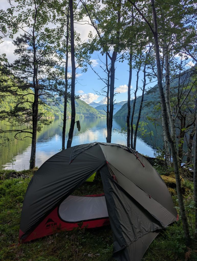
It was slow going, and a little bit sloppy in places, but the ground eventually evened to something that approximated flat ground. It was without doubt a bog (which is why it sat outside of the farm field boundary), but there were one or two relatively dry islands of ground sitting above the waterlogged trenches, upon which I pitched my first ever wild camp.
It felt satisfying to finally get a wild camp under my belt aged 38, but there were some definite downsides to the spot. The access wasn’t ideal but I can live with that, it was the complete soaking of my shoes and socks that really lingered. I might chalk down bogs as ‘possible, but best avoided‘.
To the Fjord
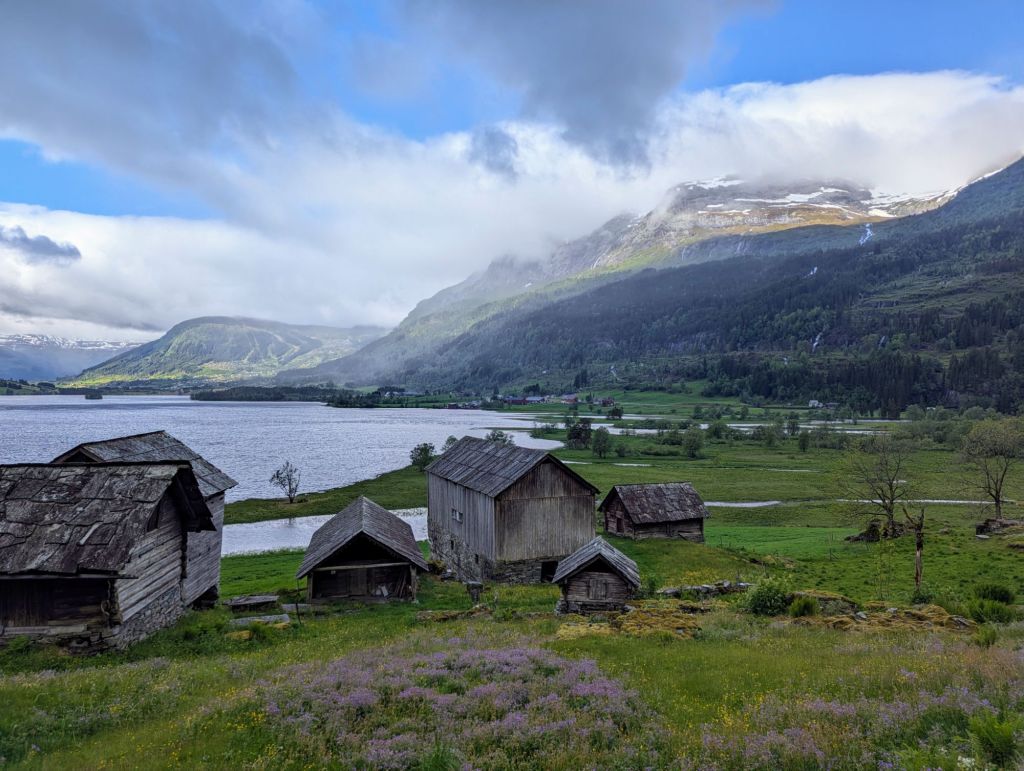
The next morning was brighter, and without a checkout time hanging over me I started the day with a short stroll to the nearby open-air museum at Nesheimstunet. It is the site of an old village where they have preserved the buildings in their original state, some of which date back to the 1600s, plus it’s free to get in (so don’t wander up the neighbours driveway looking for reception, like I did).
What struck me was the enormous roof slates the Norwegians used to use. Sure it would be bad news to get hit on the noggin by a stray modern roof slate, but these monsters would slice you down the middle like an apple. Most of the buildings themselves are made from wood, along with pretty much every day-to-day object inside. There is no shortage of wood in Norway and the Norwegians seem to make use of it wherever they can.
I packed up and set off back towards Voss, taking in a brief detour to the impressive Tvindefossen waterfall where they charge only £1.10 for the toilet, that’s a 25% Oslo discount! But if you’re a real waterfall lover and bargain hunter you should consider holding it in until Skjervsfossen just off highway 13, they don’t charge a penny for the loos and it’s a better waterfall. You’re welcome.
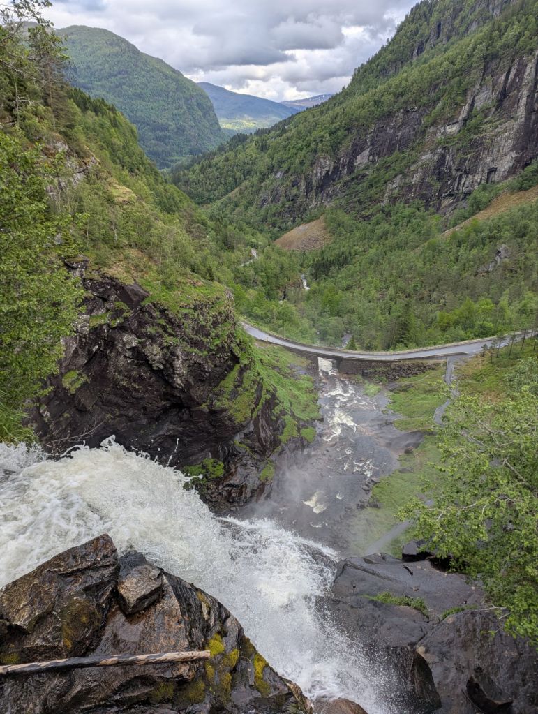
If you look at the picture above you will see a road at the bottom. This is the same road I was on and would therefore need to lose quite a bit of altitude between here and there, by descending a series of hairpin bends. I tend to ride the tight corners quite slow, but my word the bike wants to move going down the steep sections…release the brakes for a few seconds and it’s like riding The Ultimate rollercoaster at Lightwater Valley (RIP), the acceleration and momentum is immense. Having already seen and heard the waterfall, I would soon be riding straight through it as clouds of misty spray drifted away from the foot of the falls across the bridge. Quite the sensory experience.
My plan was to go through the city of Bergen at some point, so it would make sense to approach it from the south before continuing north on my original coastal route. Voss is actually north east of Bergen, so I would have to go down to come up. Come to think of it, this would be a lot easier to visualise with a map:

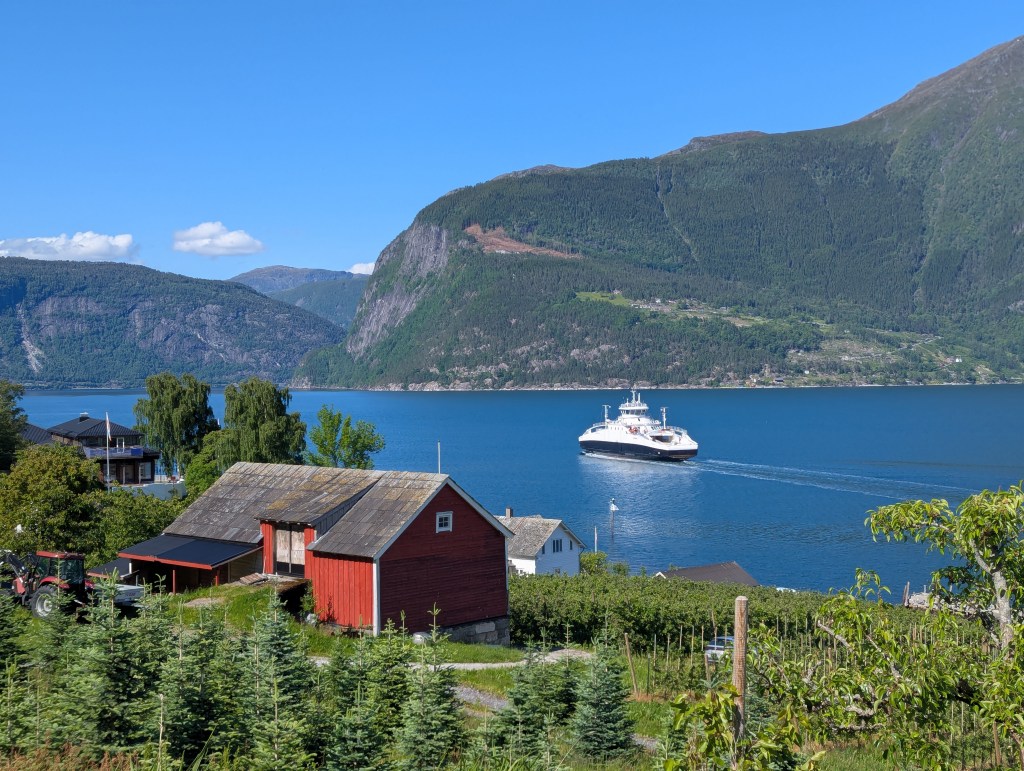
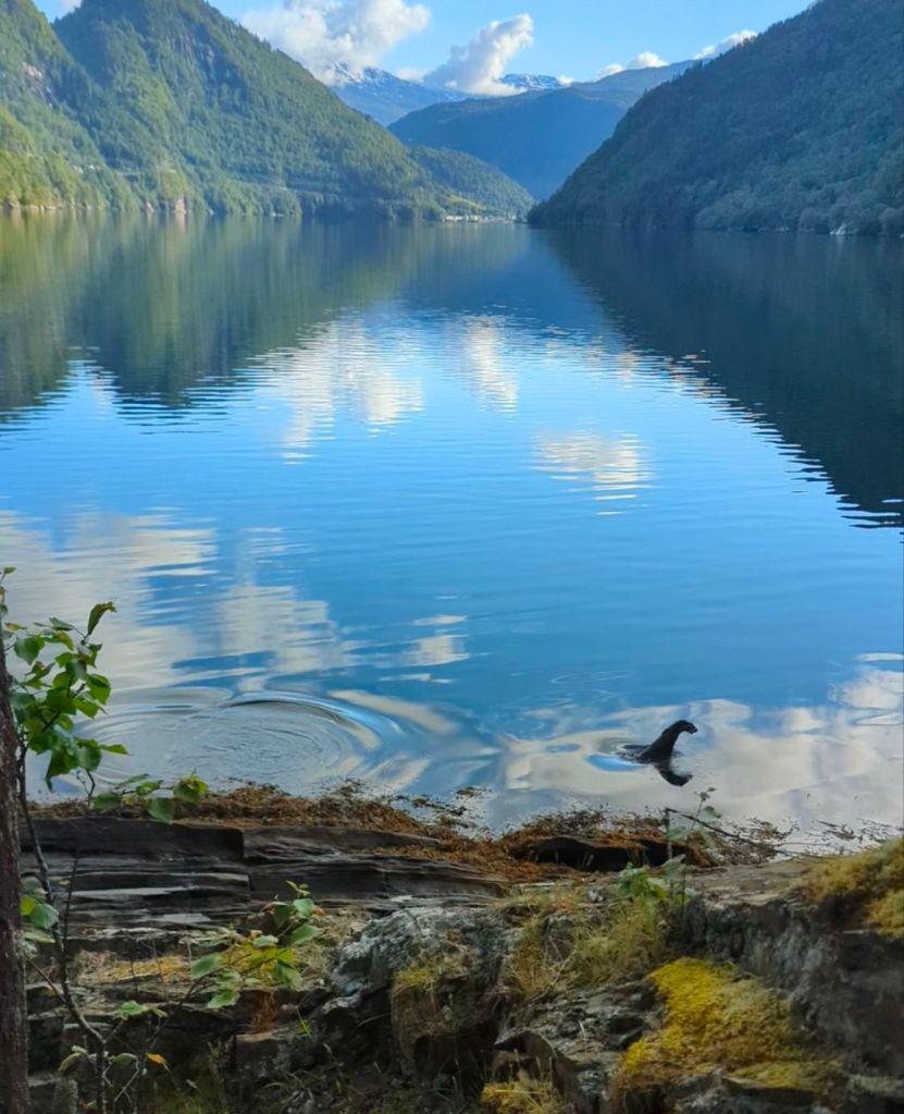
As you can hopefully see by the red line on the map, I was now heading towards a narrow stretch of water and the village of Granvin. With no intention of stopping I was set to pass straight through and see where I ended up in an hour or so, but my eye was drawn to an impressive timber yard at the mouth of the river. The yard was equipped with wat appeared to be loading docks, there was a mild scent of salty-fishiness in the air, and the shoreline boulders were covered with dark seaweed – I had found my first fjord.
What also caught my eye was a small wooden construction next to a few picnic benches, intended presumably for family BBQs and such like. Amazingly it had electricity sockets where I could charge my phone, but the location wasn’t suitable for camping being in direct view of some very well kept looking houses. The map showed a small road on the east bank of the fjord which was effectively a dead end – leading to only a few houses before disappearing into nature – which sounded like perfect camp spot hunting grounds.
The road quickly degraded to gravel, making movement slow; to my right were steep drops onto large seaweeded boulders, to my left 45° slopes covered in dense pine forest – not exactly ideal camping terrain. I briefly notched down a grassy passing place as a ‘maybe’, but soon scribbled it out when it occurred to me that my tent is actually quite well camouflaged: wild camping is challenging enough without people inadvertently driving through your tent as they politely wave through an oncoming vehicle.
I came across a slight narrowing of the fjord where the protruding land looked less steep and bouldery. The peninsula extended a few hundred metres away from the road so I hopped off the bike to review the area on foot. Certainly too awkward to ride or push the bike fully-loaded, it would require several back-and-forth trips with the panniers, but I had found a spot.
This was quite a step up from camp 1. Although my feet still got a bit wet from all the traipsing back and forth it felt worth it this time, especially in the dry and sunny morning weather. I sat down on the least damp rock available and began to make coffee.
SPLOSH.
That was odd. There had been the occasional fish jumping out of the water since my arrival, but they were only tiddlers and didn’t make much of a splash.
SPLOSH…”Squeak! Squeak!”
Clearly a mammal was on the scene, my mind began to leap to conclusions as to what it might be. Was it a seal? Nope, too small. A beaver? Too agile. It was a couple of otters out on their morning fishing expedition, ducking and diving right out of the water as they went: I managed to scramble together a short video. My assumption was they were sea otters but apparently you don’t get those in Norway, so they must have been the regular variety. The biggest wildlife moment of the trip so far; everything was coming together.
Crossing Hardangerfjord
After leaving the camp spot I called back in at the BBQ shack to charge my phone whilst I crunch through a bit of ‘tour admin’ in the morning sun. It can become a bit of an obsession keeping your devices charged, always on the lookout for a socket or usb port; cafés and pubs are usually pretty good, but transport hub waiting rooms are always worth a try if you want to keep costs down.
My plan was to keep heading south west, but rather than stick to the main road I wanted to seek more more peaceful surroundings by crossing the mighty Hardanger Fjord onto the wild looking Folgefonna peninsula.
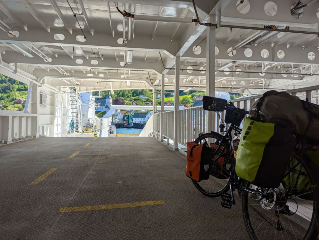
I knew there was an hourly ferry from Kvanndal to Utne, I just couldn’t work out the price for me and the bike. Norway has an incredible network of ferries going back and forth across the fjords throughout the day. They are effectively part of the road network and without them a 10 minute ferry trip could soon turn into a four hour circumnavigation of the fjord. I eventually twigged they use number plates to charge for crossing – and without such labels pedestrians and cyclists ride for free. Each crossing is like a mini cruise of the fjords…and another opportunity to charge your phone!
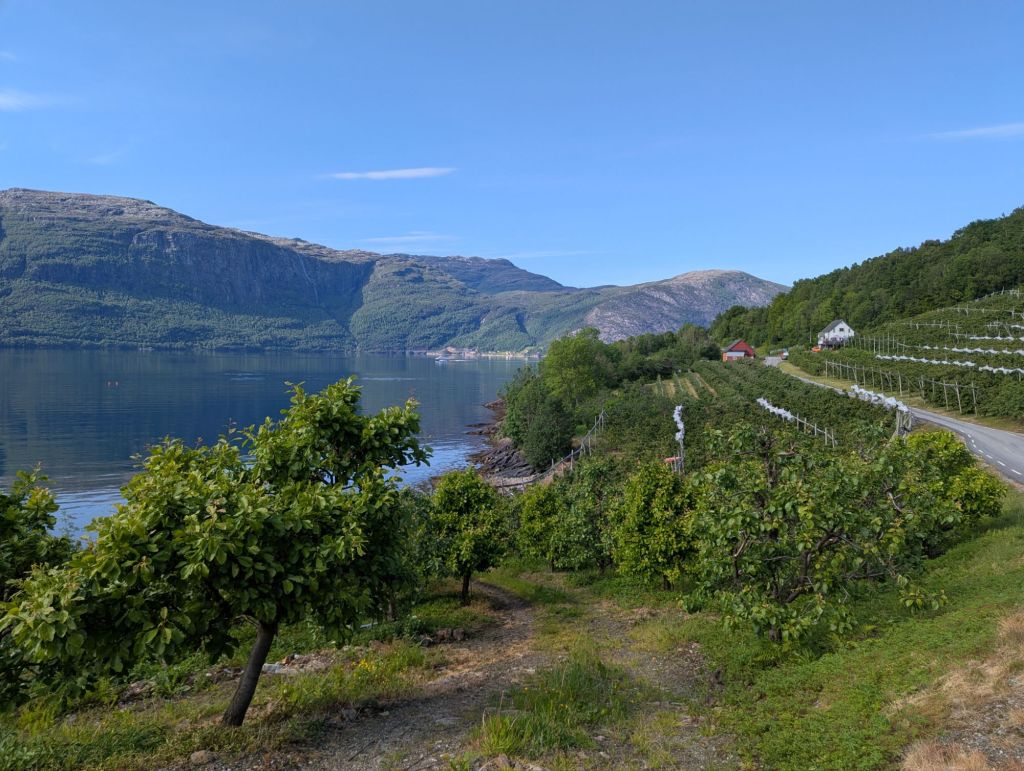
Safely across the water I began to make my way anti-clockwise around the peninsula. The glaciers and deep wilderness were much further inland; I was riding through rolling hills of apple orchards where farmers drove up and down the narrow rows of coppiced trees in tiny tractors, spraying the leaves with a fine mist in the afternoon sun as they went.
Realising I was running low on carbohydrates for my evening meal, I stopped at an unstaffed roadside kiosk with an honesty box, the kind that would sell jam or maybe free-range eggs in the British countryside. I managed to get a packet of flatbrød (flatbread), which is less of a pita and more of a cardboard poppadom: crispy yes, flavoursome…not so much. The carton of cloudy apple juice fresh from the orchards more than made up for it, even if it did look like I was bottling my own wee.
The Forest
The road kicked up into a long climb around the shoulder of a steep column of rock by the shore. Leaving behind the orchards I was riding into a coniferous forest.
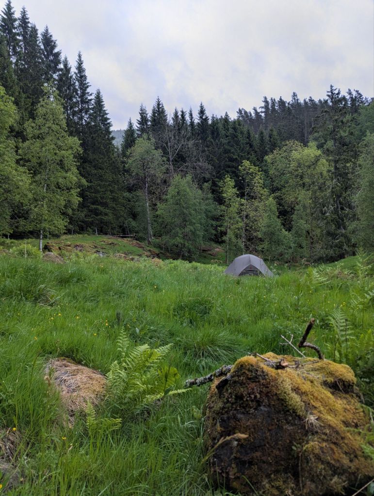
To begin with it seemed like a regular plantation of commercial spruce, but there were patches of less densely packed Scots pine trees with their characteristic orangey-red bark. I could sense a camping opportunity, but it would need another reccy on foot before I haul the bike into the woods.
The Scots pine provided beautiful surroundings, but they were growing on quite boggy and uneven ground, heavily vegetated by bilberry and heather plants. It’s the kind of terrain you could camp on if you had to, but not if you can help it. I wandered further up the forestry track and saw a small path leading into the spruce.
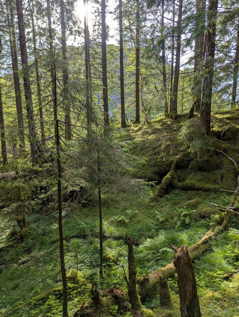
The breeze completely disappeared as soon as I entered the wood, leaving an eerie silence other than the faint trickle of a small stream. There were no animals or birds to be been, and the entire forest floor was carpeted in a thick shagpile of moss and lichen. Between the sunlight and the shadows it seemed that every shade of green in nature’s palette was on display.
After a bit of back and forth I managed to squeeze the tent in one of the bigger gaps between the trees, although one of them did prevent me from pegging down a door properly.

It was one of the scarier camp spots to begin with, probably too many Grimm fairy tales burnt into my childhood memory, but once I’d satisfied myself there were no wolves or bears preparing an ambush it was really quite a good spot. The moss carpet provided soft cushioning for sleep, there was shelter from the elements, and it was peaceful. Except the forest was not completely bereft of animal life – as word got out of my presence, the local midge population descended for a celebratory feast. It was the first battle of an ongoing war, and that evening the midges came out victorious.
Despite the midges I could see myself camping in woods again, especially if I had a bit more fly protection. The next morning I packed up and headed for the ferry crossing at Jondal, passing through more stunning natural pine forest along the way. There were definitely some better camping spots, but that’s the game you play – do you take the spot in front of you, or risk pushing on and not finding a better one? The right answer will depend on your energy levels and willingness to accept you may just have to turn around and cycle back up that big hill to the place you saw earlier…are you feeling lucky?

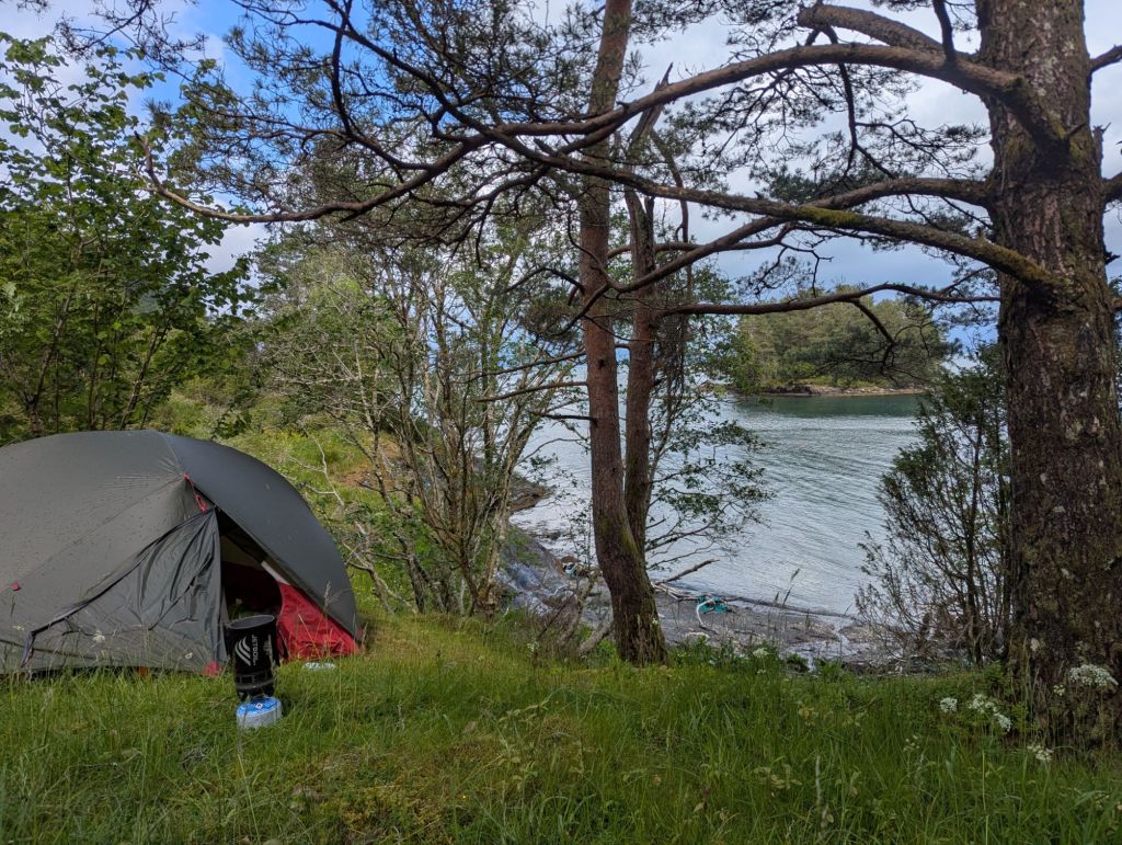
The Beach
Having crossed back to the northern bank of Hardangerfjord at Tørvikbygd I continued to straddle the water’s edge heading south west. The weather had brought plenty of sunshine but it was still unsettled, with sudden but fleeting outbreaks of light rain.
The ferry crossing was a perfect opportunity to scout potential camp spots using Google Maps’ aerial photography layer, and I had noticed a cluster of small beaches on the east side of a peninsula near the town of Mundheim. One of the beaches came briefly into view on a descent and it looked perfect: away from houses and overlooking a small uninhabited island around 100m offshore.
All I had to do was get to it. The map showed a small road leading more or less right up to the beach, so I turned off the main road and went to scope it out. The small road was more of a track, with its entrance behind a closed gate in the middle of a farmyard. Beside the entrance was a triangular road sign warning drivers of frogs, which gave me confidence it was indeed a public road, but before I could get close a farmer popped out from behind a parked tractor.
“Hi! The road, is it a public road?”
He seemed puzzled by the question, like there was an obvious reason people would not want to venture down there. Or maybe he misunderstood and my lazy reliance on everyone speaking good English might not extend to farmers, but I needn’t have worried.
“I have a few sheep in this field, but there is another way to the fjord”.
He recommended I go further along the road and turn down a different farm track, maybe one that belonged to a neighbouring farmer whom he didn’t much like. Either way I ended up on a less defined track heading towards the same beach, but away from the sheep on the other side of a small lake. The aerial footage map suggested there was a route on this side too, but it looked a bit overgrown.
The evening was still young and my energy levels high, so I decided to go for it. After stashing the bike and panniers behind a hillock out of view from passing vehicles, I threw on some trousers and a jacket to keep the ticks away and hoofed it to the beach. It was a long walk over variable terrain, including some narrow overgrown paths, but doable with multiple trips. The bike and two panniers would remain where I arrived, so I only had to carry four bags in two trips.
If you’ve ever been fortunate enough to have seen The World’s Strongest Man on TV you probably remember the Farmer’s Walk event, where contestants lift a ridiculously heavy weight in each hand and see how far they can walk in the allotted timeframe. The mechanics at play are pretty much the same here, except the weight I’m lifting is around 3% of the 160kg they have in each hand. But I had to walk along uneven paths obscured by bracken, pass through farm gates with unfathomable latches, and traverse swamps by treading on tufts of cotton grass between shoe drenching pools of stagnant water – they walk in a straight line on flat ground, the pansies!
With everything moved to just over the half-way point the heavens opened and it began to pour. I picked up the panniers and cowered on a slope under the canopy of a tree.
“Really? Seriously!?”
Having passed the point of no return I sat out the downpour and finished the job with soggy feet after trudging through the final section of long grass to the beach itself.

It may not have been the Costa del Sol, but it felt a genuine achievement just getting to the place. The fjord was remarkably still, with just the smallest of waves lapping against the dark grey sand. I found a flat area of dry sand at the back of the beach and pitched the tent, making use of washed up fishing rope to help anchor everything down where the pegs were not biting securely.
With the tent set up I could finally relax…and then it dawned on me: fjords are tidal – could I be rudely awoken by a flood during the night? My gut instinct was that the dry shelf of sand was just above high water, but gut instinct is no substitute for hard data.
The Norwegian Mapping Authority Kartverket produce tide tables across Norway, where you can use the current position from your phone to get a local reading. I started crunching numbers based on the tidal effect alone, which seemed ok, but then I noticed the actual water level forecast which also takes into account other factors such as weather. It was too close to call, especially with the error bars on their forecast, and a guaranteed way to not sleep a wink. I had to move the tent.
Rather than completely deconstruct the tent I opted to save time and effort by unpegging the corners to carry it up the adjacent grassy bank to a small plateau The plan was almost scuppered by a flurry of wind that whipped in from the fjord, and I jumped into the tent as a human anchor before it took off like Mary Poppins.
I thought about getting up at 4am to check if the high tide would have flooded my tent or not, but what would be the point? The right decision prevailed, even if it was a mega-palaver. You could argue the right decision would have been to not camp somewhere with such a grotesquely long and difficult approach from the road – but if you never push the envelope you’ll never know how much is too much: and that my friends, was too much. Did I mention I got eaten alive by midges, again!?
Night Rider
Following yesterday’s exertions I decided a long lie in was in order, especially with the rain not forecast to clear until around 11am. I lazed about nibbling on high calorie snacks and doing a bit of writing until the sun was out and my tent could properly dry. By the time I had executed the pannier shuttle in reverse it was 6pm, not exactly the 10am daily start I had coded into my spreadsheet when planning the tour.
Although it was late in the day I felt remarkably refreshed after my lie-in, so with 5 hours of daylight still remaining and an evening of perfect conditions forecast, I just wanted to ride and see where I ended up.
The wind had all but fizzled out and the evening sun lit up the forest covered mountains on the opposite side of the fjord. I wound along undulating roads past haymaking farmers and pristine white wooden churches. The road crossed a steep gorge onto the island of Tysnesøy where the bridge had a separate cycle path, allowing me to safely hop off the bike and look down into the chasm of blue fjord below. Where were all the fish? It seemed bereft of life other than the solitary seagull floating aimlessly along with the gentle tide. To be fair fjords do contain fish, they just tend to hang out near the bottom and edges where all the food is, but there is something eerie about the emptiness of that deep blue water.

On Tysnesøy I turned off the main road to a small country lane meandering uphill beside a reservoir. The evening moved into dusk and although the sunlight had waned it was still light enough to see my surroundings. There were no houses along this part of the island and no traffic at this time of day; nowhere on my trip had I felt this remote and isolated.
I buttoned up my jacket to insulate myself for a potentially chilly descent and soon enough arrived back in civilisation in the villages along the south-east coast of the island. It was getting late now, and although I could have kept going through the short night and into dawn I kept half an eye on the side of the road for potential camping spots.
Suddenly my Danish experience kicked in and my eye was drawn to a stone shelter set back about 20m from the main road: the sturdy bench was wide enough to lie down on and the south facing aspect had warmed the rocks to toasty temperature. Yes it was a hybrid between a post box and a bus stop, but it was an extremely well built and cosy one, perfect for catching a few hours of light sleep before the morning commuters turn up, and with a fraction of the faff of the tent.
It may not have been a full night’s sleep, but after a big bowl of musli coated in raspberry squirty jam and a coffee at 6am, I was recovered and ready to push on to Bergen.
My route required catching a ferry from Våge to Halhjem. With not so many hours of sleep in the bag the ferry was an opportunity to rest my eyes, so as soon as I arrived in Halhjem I hopped on the next ferry to Sandvik – a relatively long journey at 45mins – then got off, had a coffee, and caught the next straight back to Halhjem. If the ferries were super busy with passengers I would not take the piss like this, but when they are practically empty and you need a bit of time out of the elements or some charge in the phone, cruising the ferries is a great option.
The road to Bergen was well cycle-pathed but long, passing through endless sprawling towns and villages along the way. I stopped for lunch in the town of Osøyro and spotted what looked like a bike repair shop advertising 10Kr (75p) coffee…a bargain in any European country!
I’d been having issues with the spade connector of my SON dynamo rear light, which kept quietly popping out when I rode over large bumps in the road. After explaining my predicament a man promptly appeared from the back and began to examine the light, giving the connector a light pinch with some pliers before reattaching it. To my confusion he wouldn’t accept any money, so I stayed for a coffee and a chat – Livskvalitet Ski & Sykkelverksted is a local authority funded enterprise that gives adults struggling with drug addiction in the town a chance to get into a drug free environment, learn some new skills and interact with the community – so if you’re passing by on your own cycle tour why not pop by for a 10Kr coffee, they might even fix your bike. Tak!
As I made my way through the confusing multi-storey mishmash of cycle paths and roads that led into the centre of Bergen, the heavens opened and the heaviest of rain began to pour. Fortunately I had managed to link up with a fellow Brit on WarmShowers, Rob, who had kindly offered to put me up for the night. After five nights of wild camping bootcamp, it was exactly what I needed.
—————-
PHOTOGRAPHY: Voss to Bergen

Leave a comment